Exploring the Wonders of GIS in Environmental Applications
Written By:
Roshan Akther, Environmental & GIS Consultant, Terra Nexus
In an era demanding an innovative and comprehensive approach to balance the ongoing relentless development challenges with nature, Geographic Information Systems (GIS) emerged as an ally proving to be a powerful planning tool. While the concept of capturing the location of spatial phenomena with its inherited characteristics may appear simplistic, the remarkable results and unparalleled versatility of applications that GIS offers have changed the way planning was historically approached. Through the integration of cutting-edge Remote Sensing (RS) technologies with dynamic spatial analysis capabilities, GIS unlocks enormous application potential in the environmental sector, steering us towards informed decision-making in environmental planning. It empowers the decision-makers to successfully navigate development challenges whilst ensuring environmental protection.
In the words of Jack Dangermond, the visionary Founder and CEO of Esri, “The application of GIS is limited only by the imagination of those who apply it.” The geospatial approach should not be limited to just mastering the software but necessitates critical spatial thinking to unveil the true potential of the technology. Development of innovative environmental planning requires a combination of software expertise, a deep understanding of the intricacies of environmental sciences and the interconnectedness of all environmental factors.
It is essential to perceive GIS not merely as a tool but as a paradigm for scientific thinking to address environmental challenges. The critical spatial thinking coupled with the technical expertise of handling the software should go in hand with effective problem-solving and enhanced decision-making in any complex spatial context.
GIS is showcasing its strength in tackling pressing environmental challenges, combining innovation and management seamlessly. The abundance of Geospatial data encompassing aerial photography, multispectral and hyperspectral imageries, LiDAR (Light Detection and Ranging), SAR (Synthetic Aperture Radar), imagery captured by unmanned aerial systems (UAS) or drone imageries unlocks the possibilities for diverse environmental applications. The availability of freely accessible imageries, satellite-driven pre-processing data and browsers like Google Earth ensure the much wider usage of spatial data. This article aims to outline various environmental applications using GIS and how they can be used in guiding environmentally conscious developments.
1. Land Use Planning
Effective land use planning is essential for several reasons, as it serves as the backbone for achieving sustainable development and enhancing overall community well-being. It is also crucial for improving quality of life, infrastructure development, economic prosperity, social equity, and the preservation of natural resources. GIS unlocks a diverse range of applications and capabilities that significantly enhance the efficiency and precision of land use planning.
Proper development planning demands a thorough understanding of the site- its environmental elements, soil composition, geology, hydrology, human geography, climate, physiography, existing infrastructure etc. Evaluating which areas are conducive to development, understanding environmental impacts, and assessing how proposed activities would affect development and required mitigatory measures are crucial to achieve comprehensive planning objectives.
GIS plays a key role in rapidly assessing the large areas that otherwise consume significant time and resources. Even though it does not substitute site visits or required field surveys, GIS provides a comprehensive understanding of the project site to formulate focused and efficient survey efforts.
Land use planning must integrate and consider multiple factors for planning sustainable development activities. For example, the construction of roads or housing projects in low land may address transportation and residential needs but could intersect with sensitive wildlife corridors or create drainage/flooding problems. Hence, optimal resource allocation by integrating various factors, becomes paramount. Multicriteria decision-making (MCDM) models such as the Analytic Hierarchy Process (AHP) OR Fuzzy AHP (FAHP) are widely used in such applications. They integrate multiple influencing factors, establish weights through pair-wise comparisons and weighting matrices, and create spatial models. These models assist planners in solving complex land use planning challenges. The GIS platform, capable of integrating data from numerous sources across diverse spatial and temporal scales, becomes a game changer in this process.
From assessing land suitability for a variety of purposes, understanding the land use patterns for an effective planning strategy, making intelligent decisions for optimal land use, identifying environmentally sensitive areas, selecting sites for waste disposal, optimizing resource allocation and detecting changes in different spatial phenomena — GIS empowers planners to reach a balance between urban development needs and environmental considerations for fostering sustainable development practices throughout the project.
GIS provides a holistic approach to integrating the various drivers and factors influencing urban growth, offering a detailed temporal and spatial understanding of these factors. It plays a crucial role in assessing issues like urban sprawl, changes in land cover, predicting and forecasting urban growth, and understanding Urban Heat Island (UHI) effect and urban microclimate warming. Moreover, assessing urban green space (UGS) and developing frameworks and methods to integrate multiple sources of temperature datasets provides valuable insights and understanding of the urban micro-climate, assisting in the development of a climate-responsive design.
Over the years, urban growth is uncontrolled and uncoordinated and the environmental, economic, and social impacts of the land-use change and urban sprawl have been accelerating. Recent advances in this field accommodate deep learning and Object-Based Image Analysis (OBIA), offering detailed landscape studies and accurate insights, overcoming the limitations posed by pixel-level spectral heterogeneity. Also, machine learning approaches like Random Forest algorithms are becoming popular in urban/land use forecasting models in GIS platforms.
Furthermore, GIS proves its capacity to develop a model that integrates environmental, social, and economic datasets for an in-depth understanding of urban morphology and its historical evolution for facilitating effective management of development activities. Additionally, GIS advances in identifying the requisite policy intervention to ensure appropriate management of the urbanization process. There is an inevitable need to address this complexity for better environmental management and sustainable land use planning by leveraging spatial technologies to the fullest for developing resilient urban ecosystems.
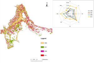
Figure 1‑1: Urban sprawling analysis in the Kandy district of Sri Lanka (1996-2011) using ERDAS Imagine and ArcGIS software – performed by Roshan Akther
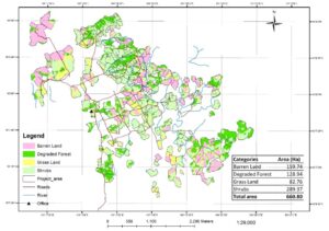
Figure 1‑2: Land use for Pakkading, Laos VCS (Verified Carbon Standard) project in 2007- performed by Roshan Akther
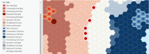
Figure 1‑3: Emerging hotspot analysis for graffiti incidents in New York using Esri (2023) training tutorial- performed by Roshan Akther
2. Natural Resource Management/Conservation
Integrating GIS technology in natural resource management and conservation yields effective supervision and monitoring capabilities. In an era marked by escalating ecological challenges, habitat shifts and rapid population growth, the imperative for effective decision-making in natural resource management is essential. From the vast expanses of forests to the depths of oceans, GIS applications provide resource managers with in-depth information for better management plans.
GIS provides powerful tools and applications addressing natural resource management challenges ranging from real-time monitoring and visualization, time series analysis, prediction models, suitability models, precision mapping, sustainable resource extraction and so on.
2.1 Soil and Geology
GIS is widely used for soil and geological mapping, offering insights for diverse applications. It aids in understanding the distribution of soil types, assessment of soil degradation and conducting detailed analyses of soil quality parameters such as pH, acidity, EC, organic matter, and nutrient levels through appropriate interpolation techniques. The outcome of this analysis provides valuable information in determining the suitability of the project area for agricultural and/or construction potential.
The integration of spatial data comprising soil type, soil composition, moisture content, crop data, topography, and various parameters is pivotal in establishing landscaping and irrigation requirements. These multi-criteria models serve as comprehensive tools for precision agriculture, assessing soil health, the design of irrigation systems, planning and improving existing utility distribution systems. Moreover, identifying the soil type, quality and distribution extends its applications to hydrological modelling and erosion risk assessments.
GIS not only provides the overview but also captures the trend of geological settings through structural contour maps, and 3D subsurface models. Additionally, GIS assists in hydrogeological investigations, tracking pollutant movement, and analyzing groundwater flow with the utilization of geotechnical data. The development of comprehensive databases comprising geological and geotechnical information substantially improves the decision-making processes in construction projects.
GIS plays a crucial role in geotechnical studies by evaluating the stability of the areas for construction and providing insights into construction design by combining different geotechnical parameters. It also aids in terrain analysis, risk assessment, identifying appropriate locations for construction/development projects, and assessing the best-engineered solutions for erosion control, land reclamation, etc. Furthermore, GIS provides the spatial interpolation capability to generate continuous thematic maps utilizing geotechnical data, it is very useful to overcome the challenges when collecting several on-site samples is not feasible.
Providing a good understanding of geological features and composition, GIS further enhances its applications in identifying valuable resources for extractive industries. GIS can analyze the reflective properties of minerals to create suitable indices, aiding in the precise identification and mapping of mineral resources. It also facilitates the development of resource estimation models, identifying the area for conservation of essential geological resources. By providing a detailed understanding of the subsurface conditions and available resources, GIS enables informed decision-making regarding the placement and design of industrial facilities. This holistic approach supports environmentally sustainable practices and efficient resource management in extractive industries.
2.2 Water Resources Management
2.2.1 Marine
GIS can integrate multiple remote sensing data sources, contributing to a comprehensive understanding of various marine dynamics. GIS enables an array of applications listed as follows:
- Analyzing ocean current and circulation patterns
- Evaluating wind patterns
- Assessment of geomorphology
- Coastal erosion studies
- Marine habitat mapping
- Sea Surface Temperature (SST) monitoring,
- Pollution monitoring (turbidity, salinity, dissolved Oxygen etc.)
- Detection of oil spills and tracking
- Assessment of sedimentation
- Nutrient runoff models
- Monitoring of wetlands and estuaries
- Development of hydrodynamic models and hydrographic analysis
- Assessment of sea level rise and forecasting associated impacts
- Analyze underwater archaeological sites
- Assisting in offshore exploration activities
- Analyzing the anticipated impacts on the marine environment by proposed development activities.
These applications are essential in gaining valuable insights into the complex interactions within marine environments and linked hazards to the surrounding terrestrial communities to develop sustainable urban planning strategies.
2.2.2 Terrestrial
In terrestrial water resource management, GIS provides immense capabilities in watershed management, ensuring the sustainable use of water resources. Applications like assessing the water quality parameters using interpolation techniques or regression models, identifying the potential sites of groundwater and aquifer recharge through weighted overlay/MCDM approach all provide the essence for optimal allocation and use of water resources in projects. By analyzing subsurface geology, terrain, precipitation and water resources accessibility, authorities can implement strategies to safeguard water quality and availability.
GIS offers powerful tools for developing hydrological models to explore the interaction between surface and groundwater, runoff and sedimentation models, enabling the estimation and forecasting of drought hazards, supporting evapotranspiration models and contributing to integrated water resource management. It also assists in developing optimal drainage and stormwater management facilities by analyzing the terrain, climatic data, land use and hydrological characteristics. Investigating water networks and improvements can be streamlined through GIS by identifying the disconnection or vulnerable points in the system. GIS also facilitates the identification of critical areas for water conservation and helps prevent over-extraction, contributing to the long-term sustainability of this vital resource.
2.3 Biodiversity conservation
2.3.1 Terrestrial
The assessment and conservation of biodiversity becomes an integral component of any development activity to sustain the ecological balance. Anthropogenic activities, directly and indirectly, impact surrounding ecosystems.
GIS not only facilitates real-time monitoring of individual species with the utilization of higher spatial resolution imageries but also produces a number of habitat proxies. These models consider the intricate relationship between species’ preferences, encompassing climatic conditions, soil composition, nutrient requirements, landscape history, habitat connectivity etc. and facilitate target surveys and monitoring strategies.
Well-developed habitat proxies or ecological indicators such as NDVI (Normalized difference vegetation index), LAI (Leaf Area Index), NDMI (Normalized Difference Moisture Index), EVI (Enhanced Vegetation Index), EWT (Equivalent Water Thickness), SAVI (Soil Adjusted Vegetation Index), Land Surface Temperature (LST), NDWI (Normalized Difference Water index), foliar Nitrogen estimation, C: N ratio models are a few habitat proxies utilized in ecological modelling and habitat suitability analysis. The integration of these indices can be achieved through multiple criteria analysis or Principal Component Analysis (PCA) or hotspot analysis. Additionally, time-series assessment of ecological factors like forest fires or disturbances can be developed using algorithms such as LandTrendr segmentation which then be correlated with species distribution to produce comprehensive habitat suitability models.
GIS also plays a pivotal role in biodiversity conservation efforts by assisting spatiotemporal habitat loss assessment, understanding organisms’ behavioral patterns through GPS tracking of collared animals, identifying migration/movement patterns and mapping the distribution of species. The application of GIS further extends to habitat fragmentation analysis, change detection analysis, assessment of the risk of extinction, evaluation of habitat patches and assessment of species richness. GIS also facilitates the investigation of biodiversity hotspots and the delineation of conservation corridors. Moreover, the integration of climate trend models with species distribution, the identification of suitable refugial habitats, and the analysis of space-time patterns are indispensable components for proactive conservation efforts.
The insights and findings derived from the above-mentioned analyses help planners and conservationists make informed and effective development decisions ensuring sustainable and responsible development practices.
2.3.2 Marine
GIS plays a key role in monitoring and managing marine ecosystems by offering a multitude of application capabilities to address the challenges inherent in these complex socio-ecological systems. It serves as a platform for analyzing and understanding the distribution of various marine habitats like coral reefs, mangroves, seagrass beds, submerged aquatic vegetation, and bathymetric mapping through spectral signature identification.
Moreover, additional applications encompass quantitative mapping of coral live cover, change detection of habitat or temporal coral bleaching, developing habitat suitability indices models, biodiversity hotspots, forecasting models coupled with satellite-derived data and in-situ bio-geochemical observations as well as exploring the relationship between habitat stressors (pollution, sediments, thermal stress etc.) and reef/vegetation health.
GIS also aids in assessing inter-habitat connectivity, mixed habitats assessments, studying phytoplankton/seagrass distribution, estimation of net primary productivity, spatiotemporal variation and phenological studies of seagrass to assess the primary productivity. GIS facilitates the development of climate adaptation strategies, identifying the critical condition of mangrove vegetation, assisting in rehabilitation efforts of marine organisms, monitoring protected species, assessing ideal oxygen consumption of marine species and finding suitable restoration sites to enhance ecosystem services.
Furthermore, GIS is instrumental in evaluating eutrophication status, algal bloom observation and monitoring, site selection for aquaculture, combining genetic information with spatial distribution and diversity, assessing disaster damage and planning response efforts.
All these applications supply in-depth information to gain optimal utilization while protecting marine resources through the establishment of marine protected areas.
This array of applications also extends to identifying the suitable area preferred by fish populations, performing fish stock assessments, investigating fish migration patterns, and assessing fishing productivity in a given region. These insights contribute to effective planning in the fisheries sector. In essence, these GIS applications provide a wealth of information to project developers to make well-informed environmentally conscious decisions and make an effort to align development activities with ecological protection and regulatory requirements.
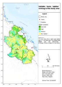
Figure 2‑1: Koala habitat suitability mapping in selected Local Government Authorities in Central Queensland, Australia as per the model developed by Runge et al. (2021)- performed by Roshan Akther
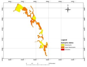
Figure 2‑2: Eutrophic status of Batticaloa lagoon of Sri Lanka using weighted overlay- developed by Roshan Akther in 2016 by generating dummy water quality parameters datasets.
3. Forestry
GIS technology is a game-changer in the pursuit of sustainable forestry practices, offering a data-driven approach. By providing a platform for the integration of environmental factors, GIS facilitates the development of a robust model contributing to optimal forest planning. It also facilitates tree logging or harvesting activities performed with minimal ecological footprint while ensuring the protection of biodiversity and ecosystems. Real-time monitoring capabilities of GIS play a decisive role in forest conservation efforts. GIS ensures the timely intervention and implementation of appropriate measures in the face of challenges like disease spread, illegal logging, deforestation, and encroachment activities in order to mitigate potential environmental damage.
GIS is not limited to monitoring; it rather contributes to the development of enduring solutions. It empowers applications such as mapping fire-prone zones, assessing forest fire severity using NBR (Normalized Burn Ratio), identifying suitable reforestation areas, estimation of above-ground biomass and forest carbon reserves, developing forest habitat proxies, forest inventory management, and invasive species distribution supports to devise management strategies to protect forest ecosystems and surrounding communities.
GIS offers a variety of vegetation-related indices and model development for monitoring forest health. These include assessment of greenness, leaf area, canopy water content, leaf chlorophyll content, evapotranspiration, net primary productivity, foliage projective cover, tree density, height measurement using LiDAR dataset, foliage nutrient estimation etc. This wealth of information enables comprehensive monitoring and analysis of the health and dynamics of forest ecosystems.
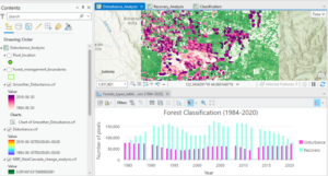
Figure 3‑1: Forest disturbances and recovery analysis in the West Cascades ecoregion in Oregon using Esri (2023) training tutorial – performed by Roshan Akther
4. Environmental assessments and monitoring
Environmental studies and assessments are imperative for developing projects all over the world aiming to minimize and propose mitigatory measures for anticipated environmental impacts. GIS stands out as a powerful technology in this domain, offering remarkable capabilities in assessing the environmental impacts of the proposed development activities and real-time monitoring for developing simulation models. Moreover, it can act as a guiding force for project owners and consultants throughout the project lifecycle- from impact studies, and construction to operation, restoration and sustainable maintenance or closure. Its application spans a wide range of activities, including appropriate site selection, evaluation of environmental impacts, project design, identification of environmentally sensitive areas, and adherence to environmental criteria.
GIS also includes centralized monitoring and real-time data collection capabilities of various environmental parameters. It enables statistical analysis of collected spatial data, planning of remediation activities, formulation of runoff models, topographical analysis, baseline surveys and spatiotemporal monitoring of flora and fauna. It further facilitates the examination of geomorphological characteristics and changes, hydrological and vulnerable area assessments, tracking pollutant sources, evaluating contamination extents, and devising strategies for cleanup and prevention.
It can be utilized in air quality monitoring using emission data from nearby stations, tracking pollutant sources, and developing air quality index or hotspot analysis to identify the region with high levels of air pollutants. It also helps to produce models that integrate emission data and meteorological data to identify trends, devise appropriate pollution control initiatives, and assess compliance against set environmental criteria.
By visually presenting spatial data, decision-makers can implement targeted measures in real-time, enhancing the effectiveness of environmental safeguards. The recent advancements in Web GIS technologies facilitate users to develop outstanding mobile and desktop applications for locational intelligence, coordinated data collection, real-time data feeds and monitoring through various web-based spatial analyses.
Moreover, GIS empowers the organization for workforce optimization and operational awareness of the environmental impacts of any proposed activities. It offers diverse analysis and modelling approaches to uncover plausible environmental impacts, compliance monitoring and devise mitigation measures with high accuracy and precision.

Figure 4‑1: Mobile Data collection application for bird watching using ArcGIS Survey 123 Developed by Roshan Akther in 2016
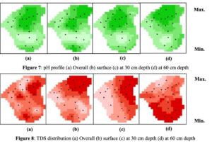
Figure 4‑1: Mobile Data collection application for bird watching using ArcGIS Survey 123 Developed by Roshan Akther in 2016
5. Climate Change Mitigation
In the face of climate change acceleration and the planet’s warming trend with the experts’ warning on the possibility of surpassing the critical 1.5°C planetary boundary due to increasing energy imbalance, the adoption of GIS emerges as a key technology in mitigation strategies and effective policy making.
GIS steps in by integrating climate data and time series change detection, offering valuable insights into future scenarios, and aiding policymakers in devising adaptive strategies. GIS provides the platform to develop numerous climate change prediction models using random forest algorithms, performing emerging hotspot analysis using space-time cubes (multidimensional raster), identifying patterns, climate change-based risk assessments, monitoring carbon reserves and approaching climate problems by incorporating all influencing environmental factors.
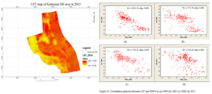
Figure 5‑1: Assessment and comparison of LST with NDVI over the years in Kalmunai Divisional Secretariat area of Sri Lanka – performed by Roshan Akther for his MSc research (Akther, 2017)
6. Disaster management
GIS serves as the ultimate platform to monitor the localities which have a higher susceptibility to natural disasters. It also offers insights for crafting emergency plans, restoration efforts, reaching affected people in advance, formulating recovery plans and proactively preventing future disasters through effective implementation strategies. This versatile platform provides a historical assessment of disasters, conducts trend analysis, and predicts areas prone to disasters.
Specifically, GIS can delineate landslide vulnerability zones, predict earthquakes, analyze coastal erosion and shoreline changes, conduct what-if scenario analysis based on historical data and trends, flood forecasting, identify the emergency shelter location and predict environmental impacts and pollution resulting from natural disasters. These capabilities prove invaluable in informing authorities to take proactive and adaptive measures to create resilient communities and ecosystems in the face of natural disasters. Adopting these methodologies in development activities for anticipated disasters facilitates robust emergency preparedness and ensures efficient mobilization of the workforce.
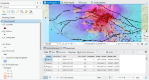
Figure 6‑1: Earthquake impact assessment using Esri’s Northridge earthquake in 1994 datasets- performed by Roshan Akther
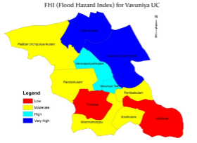
Figure 6‑2: Flood hazard vulnerability assessment using the MCDM approach in Vavuniya Urban Council area, Sri Lanka – performed by Roshan Akther (Akther and Tharani, 2016)
7. Citizen Science
GIS technology provides a platform to allow citizens to actively participate in environmental monitoring and reporting to the relevant agencies in real-time through web/mobile-based applications. Whether it is documenting local biodiversity or reporting pollution incidents, GIS empowers individuals to become guardians of their environment, fostering a sense of collective responsibility. Such base information is crucial in developing national-level environmental conservation and protection initiatives.
8. Challenges
While GIS empowers its users to explore numerous applications in environmental management, challenges like data accuracy, accessibility and interoperability persist to some extent. Addressing these challenges requires collaborative efforts involving all stakeholders including governments, private sectors, industries, environmental institutes/organizations, and developers to establish standardized protocols for data sharing and collection. Moreover, the challenges necessitate technological innovation and policy development to enhance spatial data accessibility and quality. As this technology continues to evolve, the solutions to these challenges can be anticipated to further fine-tuning the applications’ potential.
Looking ahead, the future of GIS in environmental applications is very promising. Coupled with the latest advancements in remote sensing technologies, machine learning, and artificial intelligence, GIS applications in environmental science and urban planning are becoming essential for effective and resilient urban ecosystems. Furthermore, the integration of GIS with such emerging technologies facilitates a more holistic approach to resource management, which directs a comprehensive data-driven decision-making process and fosters a balance between human needs and environmental conservation.
9. Conclusion
In conclusion, GIS is not just a technological marvel; it is one of the areas guiding us toward a greener, more sustainable future. With the ever-evolving challenges and issues in environmental management, GIS emerges as a beacon of hope, reminding us that the marriage of GIS technology and environmental management is not only possible but imperative for the well-being of our planet.
So, let us leverage spatial tools and technology to their fullest potential for enhanced decision-making, projecting a direction toward a greener and more sustainable planet with development initiatives.
References
Akther, M. S. R. 2017. Assessment of Land use/ Land Cover Changes and Its Impacts on LandSurface Temperature in Kalmunai DS area of Ampara District, Sri Lanka. PGIA, University of Peradeniya, Sri Lanka.
Akther, M. S. R., Mohideen, A.R.H., Tharani, G., Samith Indika Maddumage, M.R. & Naveendrakumar, G. 2015. Preliminary assessment and spatial distribution of selected water quality parameters at Kalmadu tank in Vavuniya District of Sri Lanka. International Journal of Development Research, 5 (6): pp. 4570-4576.
Akther, M.S.R. & Tharani, G. 2016. Flood hazard mapping in Urban Council limit, Vavuniya District, Sri Lanka- A GIS approach. International Research Journal of Environmental Sciences, 5 (9): pp. 27-31.
ESRI. 2023. Space-Time Analysis: Finding Temporal Trends [Online]. Available: https://www.esri.com/training/catalog/5cf6d5842845f65b2cca2e67/spacetime-analysis-finding-temporal-trends/ [Accessed 2023].
ESRI. 2023. ArcGIS Pro Basics [Online]. Available: https://www.esri.com/training/catalog/5cad02469b1f4010cad9ac46/arcgis-pro-basics/ [Accessed 2023].
Hong Xu & Jeff Liedtke. 2023. Monitor forest change over time [Online]. Esri. Available: https://learn.arcgis.com/en/projects/monitor-forest-change-over-time/ [Accessed 2023].
Runge, C. A., Rhodes, J. R. & Lopez-Cubillos, D. S. 2021. Mapping koala habitat for greater Queensland report. Brisbane: NESP Threatened Species Recovery Hub Project.